|
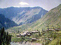
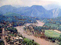
 Situated at the confluence of the Jhelum and the Neelum rivers Muzaffarabad the capital of the State of Azad Jammu and Kashmir is at a distance of 138 km from Rawalpindi and 79 km from Abbottabad. Surrounded by mountains, it looks like a walled town. It is the administrative capital of Azad Kashmir. Behind the Secretariat to the east is a road climbing above the town from where one can walk upto Pir Chinasi at 2,900 meters with good views of the Jhelum Valley and the higher mountains above the Neelum to the north. From the cool on the Abbottabad Road, you can walk along the ridge looking over the Jhelum and Kunhar Situated at the confluence of the Jhelum and the Neelum rivers Muzaffarabad the capital of the State of Azad Jammu and Kashmir is at a distance of 138 km from Rawalpindi and 79 km from Abbottabad. Surrounded by mountains, it looks like a walled town. It is the administrative capital of Azad Kashmir. Behind the Secretariat to the east is a road climbing above the town from where one can walk upto Pir Chinasi at 2,900 meters with good views of the Jhelum Valley and the higher mountains above the Neelum to the north. From the cool on the Abbottabad Road, you can walk along the ridge looking over the Jhelum and Kunhar
rivers.
 Past the Red fort, crossing Neelum river at Ghori, a few km away is 'Makra mountain' 3,890 meters which is visible from Past the Red fort, crossing Neelum river at Ghori, a few km away is 'Makra mountain' 3,890 meters which is visible from
Muzaffarabad and continues on to Shogran in the Kaghan Valley. This is a superb short trek, although you need to camp overnight halfway.
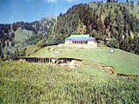
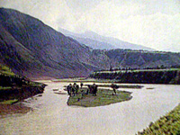
The upper Jhelum valley makes another interesting scenic excursion from Muzaffarabad. Follow the Jhelum upstream, taking the road beneath the Domel bridge. This was the old route to Srinagar. The valley is broad with raised terraces above the river. Rice and maize are widely grown. Some 10 kms out of Muzaffarabad, the river widens to from a small lake. This was created by a landslide some years ago. There is a small Angler's Hut here, which makes a pleasant picnic spot. It is possible to take boats out on the river. Book through the Tourism Department in Muzaffarabad.
 The city was founded by Sultan Muzaffar Khan of Bamba dynasty and was the seat of an independent State for quite a long period under his successors. The city was founded by Sultan Muzaffar Khan of Bamba dynasty and was the seat of an independent State for quite a long period under his successors.
The City:
 The city is now a combination of old and new buildings and a blend of different cultures and languages. It has besides official buildings, farms, parks and the historic forts standing on the banks of the Neelum, Muzaffarabad, Mirpur, Rawlakot and Kotli are connected with Pakistan by the Micro-weave system of telephone. The city is now a combination of old and new buildings and a blend of different cultures and languages. It has besides official buildings, farms, parks and the historic forts standing on the banks of the Neelum, Muzaffarabad, Mirpur, Rawlakot and Kotli are connected with Pakistan by the Micro-weave system of telephone.
Accommodation
There are rest houses, good hotels and guest houses in Muzaffarabad city where the tourists can stay.
Bazaars & Shoping
The rather sleazy bazaar in Muzaffarabad can be explored for its walnut carvings and its Kashmiri shawls. It is sometimes possible
to get a good bargain.
MUZAFFARABAD FORT
Border skirmishes between the armies of renowned Mughal The Great Akbar and the Chak rulers of Kahsmir were common. To ensure safety of the people, and the land, the Chaks realised to raise defence posts and efficiently countered the offensives.
During the year 1949 the construction of the red fort was undertaken. It was finally completed by Sultan Muzaffar Khan the founder of Muzaffarabad city during 1646. When the Mughals overtook the Kahsmir rule, this fort lost its importance. The Mughals were more interested in Kabul, Bokhara and Badakshan. During the Durrani rule the fort again came into limelight and its importance was rediscovred.
Maharaja Gulab Signh and Ranbir Singh, the Dogra rulers, reconstructed and extended the fort for political and military operations. Towards the end of 1947 the Dogra forces filed away leaving the fort wide open to anybody.
The architectonics of the fort show that great experts in design and structure participated in its construction. It is surrounded on three sides by Neelum river formally known as Kishan Ganga. The northern part had terraces with steps leading to the bank of the river. The Eastern side of the fort was very well protected from the hazards of flood waters but some parts in the north were slightly damaged. There was an inn at the entry of the fort which has traces left now. |
